08/07/2006 04:21:41 by Administrator
From: New Port, Washington
To: Ione, Washington
Mileage: 53

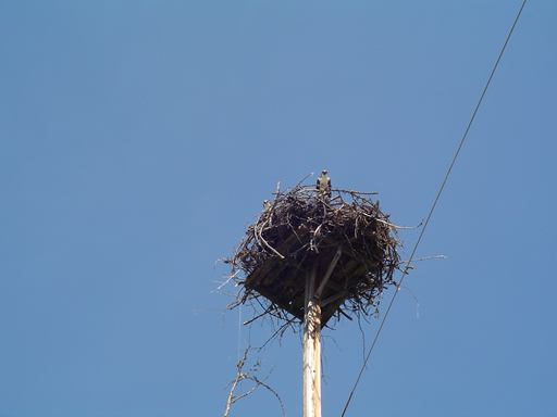
Our ride today paralleled route 20 on the other side of the Pend Oreille River on North LeClerc Road. Yet another stellar ride, we know we keep writing that sentence, but it is just . . . true. Quiet road, ospreys, turkeys, golden AND bald eagles, Selkirk Mountains, Pend Oreille River and for added enjoyment, a herd of bison!
We met a fellow northern tier cyclist, Fred, a couple of days back on Route 37, and he had warned us about road construction around Newport. Keeping this in mind, we had breakfast downtown then proceeded to the information center in Newport. The gentleman at the center was very nice, and told us of road construction on Route 20 from Usk to Cusick. After showing him the Adventure Cycling map, which showed our route on LeClerc road. He assured us that there was NO construction that way.
You are guessing correctly, 5 miles into our ride on LeClerc road we encountered road construction. While waiting for the "follow truck", we had a great conversation with the two flag women. They had seen a number of cyclist going both east to west and west to east and actually told us the major stops that we will be making and have taken on this section of the Adventure Cycling map. After about 15 minutes, the follow truck showed up, and SeeMore bravely followed behind through 1.5 miles of road construction. One section had pretty soft sand (this is SeeMore's number one fear!), but we made it through and really enjoyed the rest of today's journey.
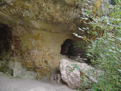
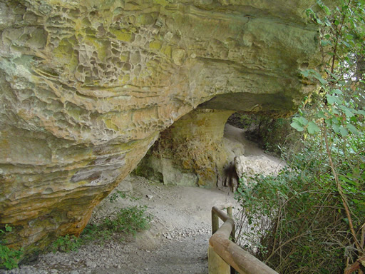
We stopped at Manresa Grotto for a rest break (the two photo today are of Manresa Grotto), it is a couple of caves carved out of the rock when the river was at this level. We then had a picnic lunch at the Panhandle Campground (USFS), yet another campground with water front sites.
Today was not all wine and roses. Noel had his first sick day of the trip. He had a pretty bad headache, and not sure if it was caused by allergies, smoke (there are multiple forest fires burning in Washington state), or some bad food. His headache finally cleared about 10 miles from Ione, and thankfully so because it reached 94 degrees at 3:00.
We spent the afternoon out of the sun, and will investigate Ione once the sun gives us a break.
Posted in Across the USA |
08/06/2006 04:20:12 by Administrator
Posted in Across the USA |
08/05/2006 04:18:40 by Administrator
Posted in Across the USA |
08/04/2006 04:12:30 by Administrator
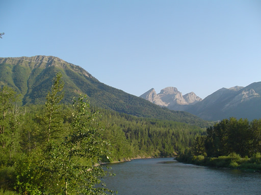
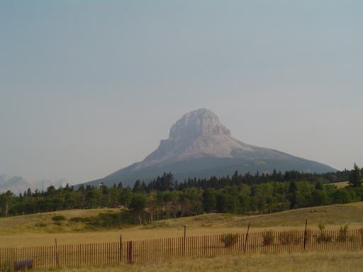
From: Eureka, Montana
To: Libby, Montana
Mileage: 68
WOW!
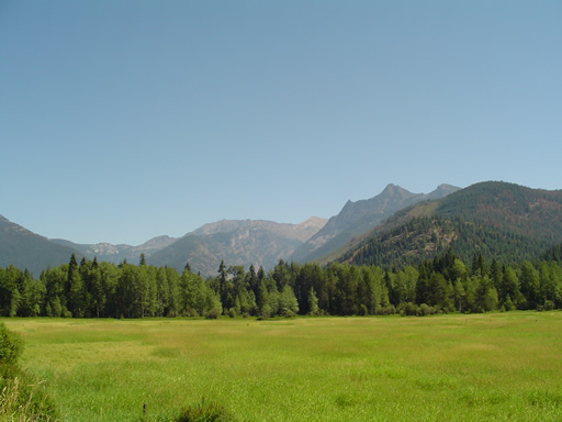
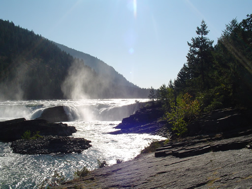
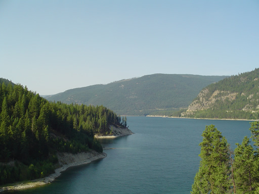
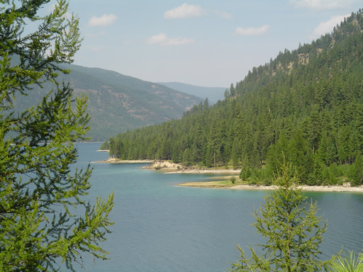
We think we found Cycling Heaven on Route 37 from Eureka to Libby. Cycling heaven is 65 miles of ospreys, bald eagles, mountains, Lake Koocanusa, Kootenai River, and a quiet road. Our eyes and brains hurt from trying to enjoy all that was around us. We found ourselves not saying anything for long stretches, just lost in our own thoughts. These two photos are all we need to explain.
We met a fellow teacher, cycling across on the northern tier. Fred Brown is biking, with his wife Gania following in a motor home, across America from west to east. You can read more about his adventures at: http://web.mac.com/fbrown5/iWeb/Bike%20Trip/Welcome.html
We took a rest break at the Libby Dam. Libby Dam is the culmination of years of effort on the part of both the United States and Canada to develop a flood control plan for the Columbia River basin. Lake Koocanusa was named by using the KOO in Kootenai River, the CAN in Canada and USA. The Kootenai River is the third largest tributary of the Columbia River, contributing almost 20 percent of the total water in the lower Columbia. The dam stands 422 feet tall and about one-half mile long and creates a reservoir (Lake Koocanusa) which provided the backdrop of our canvas today.
Posted in Across the USA |
08/03/2006 04:10:59 by Administrator
From: Fernie, British Columbia
To: Eureka, Montana
Mileage: 53
Stellar ride again, we wonder if the people living in this area could ever take all this beauty for granted. As we rode out of Fernie it was pretty crisp, probably about 40 degrees. Two mountain bikers passed us on their way to work at the ski resorts located on the south side of town. Both were in shorts and T-Shirts, where as we were bundled up. Our excuse, all of that hot weather must have thinned our blood. Blue sky and temperatures in the upper 70's followed us as we continued on route 3 traveling southwest towards Montana, and after Elko where we turned south onto route 93. Most of today's riding was flat or downhill except for a climb out of the Elk River valley where route 93 departs from the Elk River. We've seen very little wild life along this route maybe because it is so busy. We passed a roadside turnout that did in fact confirm that there are big horn sheep, moose and bear in the area. Maybe it's best that that they are not down near the busy road.
Again, route 3 was busy but didn't start picking up traffic until mid morning; by then we were close to route 93. Route 93 was smooth, wide shoulders and LITTLE to NO traffic, until the border crossing. It is amazing how much you miss the quietness when you are on the bike. Riding through the Rockies, what more can be said. Trees, river, mountains and rock cliffs surrounded us as we rode.
At Elko we stopped at the dairy bar on the corner of route 3 and 93, basically to watch the amount of traffic turning onto route 93. There was a group of white water rafters gathering for the day, and we talked to one lady about living in this area.
In Grasmere we had some cheeseburgers and fries, It was a little early but we wanted to spend our last 12 dollars of Canadian. Surprisingly, we found out that we were pretty hungry, because we ate rather ravenously.
We sailed through the border crossing, first time that it was as easy to access the USA, as it always seems to be getting into Canada. The afternoon was spent in downtown Eureka (population 1950) and visiting the Tobacco Valley Museum in town. Eureka's claim to fame is logging and the production of mucic acid. Mucic acid comes from larch trees and the best we can figure out is that it is either a type of baking soda or baking powder.
Posted in Across the USA |
08/02/2006 04:09:16 by Administrator
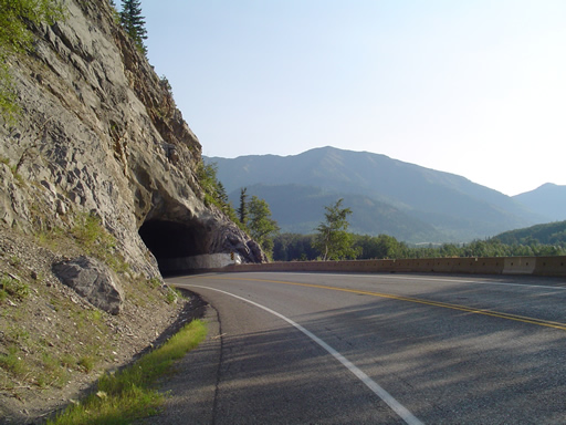
From: Blairmore, Alberta
To: Fernie, British Columbia
Mileage: 50
Easiest 50 miles on the trip, we will see? The only two challenges on our ride today were the Chinook winds and the truck/camper traffic. We remained on Route 3 today, which has nice shoulders on the Alberta side, and questionable but safe shoulders on the B.C. side. This must be the easiest pass in the Rockies. (Dad we think we found the first tunnel) We were expecting the road to climb. anytime, around every corner, and yes we had some climbing but not like any of the mountain passes we've ever seen before!
The lady at the Pincher Creek information booth yesterday said that as soon as we crossed the continental divide the headwinds would cease, we think she was messing with us, cause the lady at the next info booth said "well where do you think those winds are coming from?"
Ready to test all wind theories we went over the Continental Divide and crossed the B.C. border, but there was no road sign marking the Continental Divide and the wind didn't stop! Crownest Pass is around 4450 feet in elevation, but there is no road sign. There were road signs for logging trucks, we saw 3, however at least 30 pig/cattle trucks passed us and left our clothes smelling a tad bit like a barnyard! We saw road signs for elk in the road, but didn't see any. We saw road signs for Rocky Mountain sheep, but did not see any.
We did see bluebirds and we were surrounded by the Canadian Rockies and lakes the whole day, so all those road signs (or lack of signs) really didn't matter very much And if not for the headwinds today, we would have probably been going too fast because it was downhill or flat for 97 percent of today. Boy will we pay for this day!
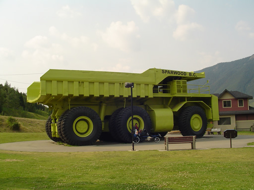
After 25 miles, we stopped in Sparwood B.C. for our second breakfast and to take SeeMore's picture next to the largest truck in the world. This is coal-mining country; it was coal mining country 100 years ago.
We arrived in Fernie (also a coal mining town) around 1:30 pm, we are not sure what is ahead of us and we are pretty tired of the truck/camper traffic so we stopped for the day. We spent the afternoon riding all over Fernie (population 5000). Fernie has mountain bike trails all over the place, nice parks, a quaint downtown, kids riding bikes safely in the streets, and a Boston pizza? Surrounded by mountains, the only drawbacks we see is that route 3 runs through the middle and (we are guessing) it is probably a tad bit cold in the winter.
Posted in Across the USA |
08/01/2006 04:07:37 by Administrator
From: Waterton, Alberta
To: Blairmore, Alberta
Mileage: 65
Well we're "officially off route". After breakfast at the hotel dining room which included views of Waterton Lake and the surrounding mountains we began our journey north towards Pincher Creek, Alberta. Using a map from the Waterton visitor center we decided that we would shoot for three major towns on our detour route. Pincher Creek, Sparwood and Fernie, Pincher Creek seemed to be the best destination for today as we did not know what to expect for climbs, wind and services. With the help of pretty good crosswinds from the south and more spectacular views of the Rocky Mountains as we rode north, we arrived in Pincher Creek at about noontime. Route 6 north was not busy at all, and a pleasure to ride.
On the way into town we met a very nice man named Pat Geale. He had pulled ahead of us to take our picture as we went by. His niece is considering a trip across Canada and he was wondering about our trip and bike. He spent many years himself wandering the waterways of Canada he appreciated our mode of travel.
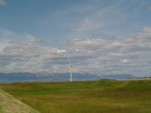
Our first stop in Pincher Creek was to the visitor center to check on rates and recommendations for the local hotels. We had a wonderful visit with the woman there who shared a ton of information about the surrounding area, weather and what it was like to live in the area. Pincher Creek and its neighboring towns are also home to a major Shell oil and gas facility and several major wind plants. It is a very nice, prosperous little town.
After circling the town a bit and checking out a few of the local hotels we decided that it was really just too early to stop for the day, so after lunch we began heading west and climbing Crowsnest Pass. Now there just isn't any getting around it, if your going west and each of the 100 or so wind turbines is pointing west you better just settle in and not fight it. So our pedals spin a little more and our speed drops to about 7 or 8 mph but we still seem to move along. Route 3 has a lot of truck and camper traffic on it, but has wide shoulders. The views from SeeMore, however, were outstanding and there were several interesting historical sites at which we stopped to visit.
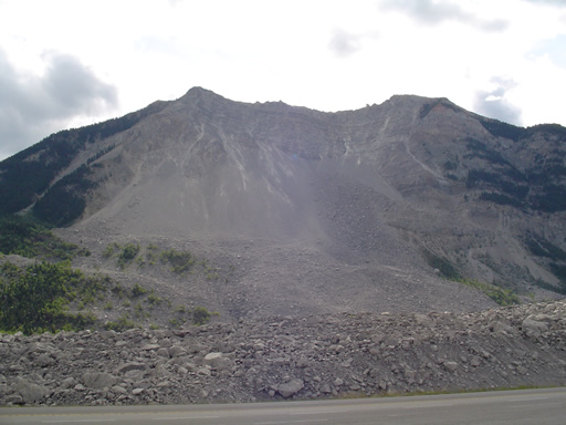
The Leitch Collieries was a site built for the Canadian Mounted police when cattle rustling became rampant in the area. Later it was used as a coal mining operation when the railroad moved westward. Not much remains of the site but hollow walls and foundations. Further up the road is the Frank Slide, which was very impressive. Frank was a small coal mining town until one night in 1903 when about 1/2 of Turtle Mountain collapsed on top of it. Today the road runs smack though the center of the landslide, with the exception of the road and railroad tracks, evidence of the slide looks as though it happened yesterday. The Rear Admiral tried to take some photos to capture it but just could not. After a great conversation with a family from Edmonton, there son has a custom built recumbent bike; we headed on up the hill.
By about 5 pm we reached Blairmore, AB and our riding limits for today. We quickly found a hotel and created quite the disruption getting the bike into the room. Bringing Seemore into a hotel is kind of like bring a horse in, especially if it isn't a straight shot to the room. It usually yields lots of questions and meeting new people so not so bad.
While at the grocery store in town we met another touring group doing the Adventure Cycling Great Parks tour. We had just enough time to exchange the basics and were invited to visit their campsite in town. Not sure who looked more exhausted but they had sixteen people to fix dinner for so we will wish them the best of travels and a good nights rest tonight.
Posted in Across the USA |