07/10/2008 13:00:00 by Administrator
From: Waterton, Alberta
To: Rising Sun Campground, Glacier NP Montana
Today: 57 miles - 842 miles total

Happy Birthday Aunt Lynn!
Buffet breakfast at downtown Waterton Villege. We both manage to make ourselves some lumberjack specials. I ate more food, then the Rear Admiral.... I was REALLY hungry. Prior to the breakfast buffet, we broke camp to blue blue skies, and by the time we were heading towards breakfast the clouds and mist had rolled in, and it was pea soup! You couldn't see The Prince of Wales, the Rockies, or even the lake. It changed in a snap of a finger.
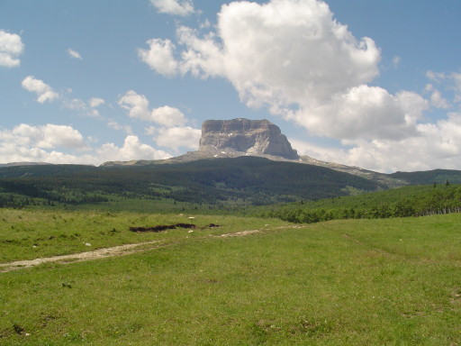
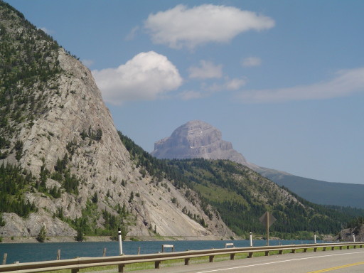
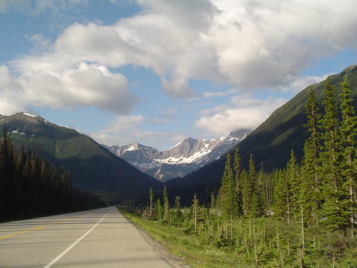
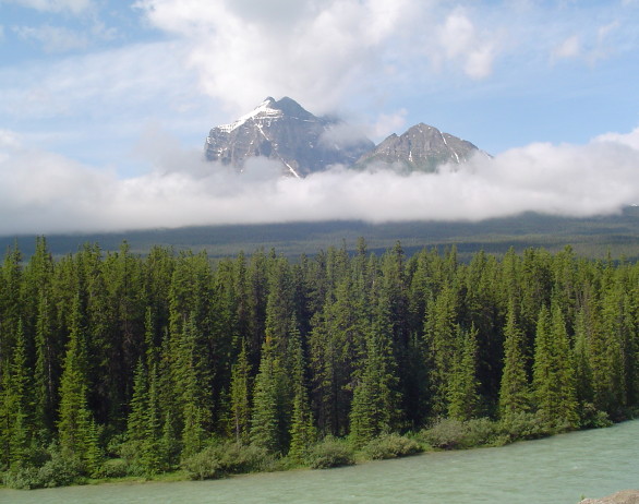
Today's climb was on Rte 6 (Alberta's side) and Rte 17 (Montana's side) which is called Chief Mountain International Highway (photo above). Even though it is not a "pass", it wasn't the easiest to get over. What you do is climb from 4200 feet to about 5300 feet in 8 miles. Then you drop down back to 4400 feet, before going up again to 5200 feet at the US/Canadian border. The first part of the climb was done in clouds and mist. We could only see about 50 yards in any direction, and had our rear light (blinky) on. Coming down it was burrrrrrr.....cold, so we put on more clothes. As soon as we started the second part of the climb, the sun came out and it was time to strip out of the extra clothes, and put on sunscreen!
We stopped only briefly, about a mile from the border to eat our oranges. We didn't want the custom agents to take ANY food away from us, so we ate the oranges! We breezed through customs, the border guard was only interested if we were bringing any rocks or firewood into the US. We thought this was a funny question since, here we are, a fully loaded orange colored recumbent tandem...and he thinks we have ROCKS or WOOD in our panniers? As soon as we got out of ear shot, the Rear Admiral and I had to pull SeeMore over before we laughed ourselves off the road. Obviously the guard never rode a fully load bike up a mountain before.
I mentioned breezing through customs, well after customs the good ole Chinook winds were back in full force. SeeMore was getting pushed around, and once he was blown from the right side of the road, all the way to the left side! We had a picnic lunch (holding tightly to our PB&J sandwiches) at an overlook . With no trees or shelter we huddled in a sunny spot on the parking lot, trying not to get blown away. Then continued to ride into the wind until we had to escape for a while, in a cafe in Babb......cherry cheesecake sure helps!
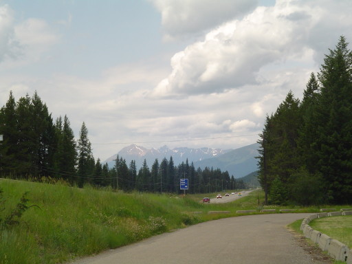
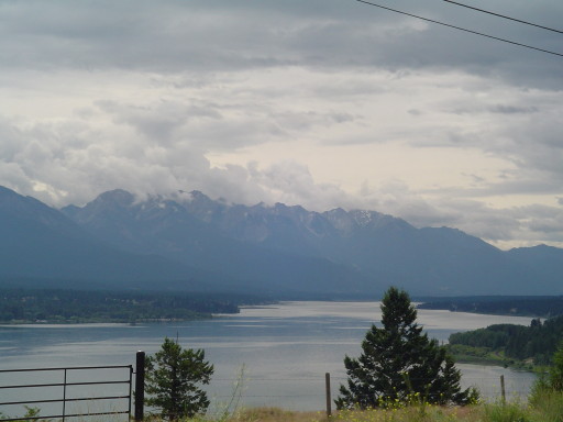
We have the Prince of Wales II erected at the Rising Sun campground, and are about to search for food. There is a lot of evidence of the 2006 forest fire that prevented us from doing the Road to the Sun on our trip across country. But it looks like they somehow managed to save portions of the standing forests, so it doesn't look as devastating as what we have seen in Yellowstone etc. Tomorrow we will try to get up and over Logan Pass, oh boy!
Posted in North to South Tour |
07/09/2008 13:00:00 by Administrator
From: Pincher Creek, Alberta
To: Waterton, Alberta
Today: 40 miles - 785 miles total
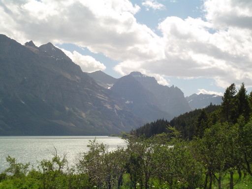
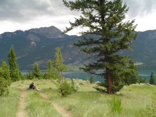
We now have a nickname for our tent, The Prince of Wales II. We are in Waterton National Park, and the wind is gusting from the west. It is always blowing from the west! (here on the east side of the Rockies) We had some very hard miles today. Sitting here watching the Columbia Ground Squirrels (cousins of the prairie dog?), the white tail deer, while we are all in the shade of the snow dotted Canadian Rockies....kinda makes those miles go away.
It's just plan beautiful here! We are under a shade tree, watching the white caps on the lake, and thanking our lucky stars! The Chinook winds were out of the south west today, and yes, that was or traveling direction today. We cycled Rte 6 today, with the Canadian Rockies on our right, miles and miles of farmland, and the wind in command. The foothills go up and down as you ride, and with the wind, you can not establish a cycling rhythm.
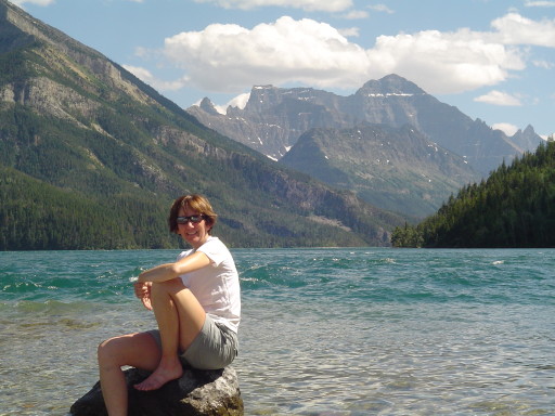
We had lunch/breakfast at the Twin Butte grocery store / restaurant (breakfast burritos). If you are traveling by there, stop in, you will not be disappointed with the food or the service. The Twin Butte stop was really the highlight of our day, until we spent the afternoon in and out of the shops in Waterton village and plain sitting around by the lake shore. Well almost, at the Waterton National Park's information house, an old man wanted to feel the Real Admiral's legs. He couldn't believe she could pedal SeeMore all the way from Edmonton! Since his wife didn't mine (you think he goes around feeling other men's wife legs?), Mary said go for it.
Two years ago on our trip across the US, the Rear Admiral and I stayed in the Grand Hotel (Prince of Wales) in Waterton, It was our 25th anniversary gift to each other. At $350 a night, a school teacher can only afford so much so this year we spent $21.50 and set up the tent (The Prince of Wales II). I'm just such a romantic guy! I don't know if the Rear Admiral is being kind, but she says the Prince of Wales II is just as good as the grand hotel on the hill. She must be really tired from the Chinook winds!
Tomorrow we head over Chief Mountain and back into the US. Even though it is not a "mountain pass" we been told it is a bit of a toughie.....we will see, hopefully the Chinook winds will take a day off!
Posted in North to South Tour |
07/08/2008 13:00:00 by Administrator
From: Fernie, British Columbia
To: Pincher Creek, Alberta
Today: 77 miles - 745 miles total
Our first stop was Sparwood, where we saw the largest truck in the world (again)....then went to the local grocery store for some snack food and Gatorade. Then it was up and and across Crowsnest Pass (4,457 ft) which was not very hard at all, except for the traffic and pig trucks...with their odor as they passed us.
We stayed on Route 3 for most of the ride today. Crowsnest Pass (above photo) has a couple of beautiful lakes, and there is a campground on the shores of one of the lakes, which looked very inviting. Imagine at the top of a pass, with a flat valley, full of cool blue water. Very inviting. We noticed on both sides of the Crowsnest pass (BC and Alberta) they have workers trying hard to eliminate the Purple Loosestrife which is taken over. We think it is a losing battle. At the Alberta/BC border we went though the Truck weigh station with all of the other "big rigs" . We weigh in at 22. We're not sure 22 whats but doesn't sound too heavy?
We had a picnic lunch in downtown Blairmore, a town after the pass. After lunch we passed through what remains of the town of Frank. In 1903, half of a mountain came down on the town killing over 70 people. Today both Route 3 and the railroad pass through huge amount of granite boulders. At any natural disaster site, we are reminded how we will never be in control of Mother Nature.
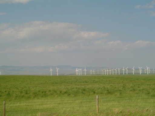
It was then on to Pincher Creek, a simple 27 mile ride, right? In this neck of the woods, they have a thing called the Chinook Winds. Let me tell you, they were blowing. Pincher Creek is BOOMING, because of oil and the hundreds of Wind Turbines they have to take advantage of the Chinook winds (see the below photo). So while we traveled south, we were blown all over the road....and our progress was slowwwwww. When we headed east, we barely had to touch the pedals! Too bad, the first 20 miles were not east bound!
We are here in Pincher Creek, at the Super 8. This might be one of the last rooms available in town AND this hotel is only half completed. We are not sure how they are allowed to have guests, with all the construction left to do on this building. To get up to the second floor you go up a staircase that is just framed - not drywall? Tomorrow we will be heading to Waterton, then Glacier National Park, so don't worry ....we will be back to camping and no internet.
Posted in North to South Tour |
07/07/2008 13:00:00 by Administrator
From: Skookumchuck, British Columbia
To: Fernie, British Columbia
Today: 83 miles - 668 miles total
We are in Fernie, again, two times in two years! But we are getting ahead of ourselves.
Today was more of route 95/93, more logging trucks, more campers, and more noise(above photo). We had an early start, on the road by 8 a.m., remember Canada doesn't wake up fully until 10. In Wasa, you ride by Bill Nye (the science guy?) Mountain. After Wasa, we rode into the town of Fort Steele and had a Gatorade and gorp at the gas station/ camp ground. We then cycled the Wardner Fort Steele Road for 20 spectacular miles. This road started out with a steep climb, and ended with a steep climb. . . but in between was a flat quiet road with The Steeples (more Rockies) in the background (right side) and cattle ranches on the left and right. We even saw our first mountain blue bird! This is a road made for cycling!
At Jaffray we stopped for lunch at "The Perk". They have hundreds of hot and cold drinks, fresh baked goodies, and a great selection for lunch. This place is EVIL, unless your burning calories on a bicycling ride! At lunch we had tandem huddle, SeeMore and the Rear Admiral were ready to go for Fernie. I wasn't, but the more I drank my white chocolate expresso frappe the more my legs were jumping at the idea. So we were off!
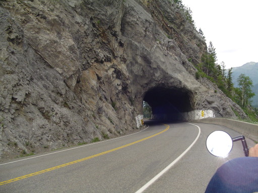
There was a big climb in Elko, but after that the climbing into Fernie was very easy. We even found that tunnel again (you were right again Dad, there are tunnels through the Rockies). Route 93 goes south to Montana in Elko so the road into Fernie is Route 3. One day I hope they close the road from Elko to Fernie to all motor powered vehicles...just for one day. Then this part of Route 3 would be a cyclist dream! Riding up through the Rockies until you see the Three Sisters (more mountains) and Fernie, WOW! But until that day comes, fighting truck and car traffic takes you in and out of paradise.
We are here in Fernie, living large in a hotel room. Wow has Fernie grown in the past 2 years. I think I remarked last time that this would be a great town (population 5,000) to put roots down....I guess a lot of people are reading this log! There is an Alpine Ski resort so most of the new construction is vacation condos. We hope it doesn't grow too much, It is a very nice town just as is!
Posted in North to South Tour |
07/06/2008 13:00:00 by Administrator
From: Radium Hot Springs, British Columbia
To: Skookumchuck, British Columbia
Today: 62 miles - 585 miles total
Go ahead, try to find Skookumchuck!
We climbed up out of Radium Hot Springs, into Invermere (9 miles on busy 95/93). Invermere is a very nice little town, population about 3000. We got new sunglasses for the Rear Admiral, wouldn't be a bicycling tour unless she loses her sunglasses at least once! We visited the grocery store, and got stuff for a picnic lunch. We talked to a number of locals, all very fun and out going people. Invermere is located on the hills on the north side of Windermere Lake (see top photo). It was fun exploring Invermere, it has a lot of things to offer.
We then rode the quiet West Side Road out of Invermere for 16 miles of bicycling joy! Lake views, mountain views, and a mixture of cattle ranches and summer/winter get-a-ways. SeeMore even crossed a cattle guard or two! We played hide and seek with the rain all day. Towards the end of West Side Road, we experienced our first liquid sunshine of the day. Not too bad, just enough to turn your shorts from a sold color to polka dotted. After West Side Road, we then cycled 14 miles on Columbia Lake Road, following the ......yup....Columbia Lake. We had our picnic lunch (bottom photo) overlooking the lake, with the Rockies in the background and a bald eagle flying by at eye level. How can we make a living doing this?
After lunch, it was dodge-ball with the rain on highway 95/93. We were very successful until about 2 miles outside Canal Flats, when it started to lightly rain. We raced into Canal Flats (out running two local Canal Flats Golden Retrievers!) and finding shelter under the porch of the local building supply store. Then Mother Nature turned the faucets on full. So we waited out the storm for 45 minutes. Route 95/93 is pretty busy but we are getting use to the noise level.
We are here in Skookumchuck, living large in a hotel room. As I am writing this, the Rear Admiral is not asleep (it's after 7:30!). We had dinner over at the local restaurant/gas station/food store/fishing equipment establishment. Try the Shook burger, and see if you can finish the whole thing. Thank goodness the Rear Admiral was there to help me with mine!
Posted in North to South Tour |
07/05/2008 13:00:00 by Administrator
From: Marble Canyon Campground, British Columbia
To: Radium Hot Springs, British Columbia
Today: 58 miles - 523 miles total
We decided to stay in the picnic shelter last night, we had just gotten everything dry, and it began to rain while we were hiking. So instead of having to pack things up again, wet...we just set the tent up inside the picnic shelter. There was only about 10 other campsites taken, and there must have been 80 empty campsites. So we stayed nicely dry, and naturally I slept like a rock. The Rear Admiral is still in the "getting used tent camping" phase of this journey.
We were up bright and early, and had everything out of the food lockups when a couple from Colorado showed up we talked about hiking, biking and Alaska. They were heading up to Anchorage to visit their daughter who is an engineer for BP. They are traveling by car with a pop-up trailer, and going almost as slow as we are stopping to hike as much as possible on the way. They had spotted some wolves on their hike the previous evening. Which is a pretty rare event.
Today's ride took us through Kootenay National Park, and was pretty quiet for most of the trip (few motor vehicle but lots of birds!). We passed through a section which in 2003, saw a huge forest fire that claimed 12 percent of Kootenay National Park. You could see were it jumped across the road, there are still scars on the pavement. These mountains were pretty much in your face all day; using a fourth grade word to describe the views....awesome! The mountains are not as tall as Jasper or Banff, but still impressive enough that a lot of pedaling was done in silence and awe. We stopped at McLeod Meadows Campground for lunch, a command decision by the Rear Admiral. It's important when doing these passes that you take a rest before ascending, eating helps also.
We made it up and over Sinclair Pass (4,875 ft) for our fourth pass in as many days! Not bad, no blood vessel popping moments. Going up the Sinclair pass you can see a lot of trees dead, from the pine beetles, a plague that is effecting the forests of British Columbia. (As we later found out this is because the forest fires are contained the trees get older and more susceptible to these bugs) There are hundreds of brown acre size ovals, all over the mountain sides. This is where the couple from Colorado, saw a pack of wolves yesterday. We did not even hear a howl, except for when SeeMore made it to the top!
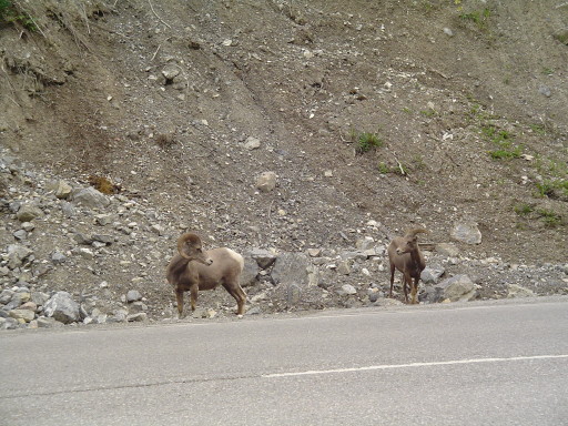
And then we went DOWN! DOWN! DOWN! No shoulder, playing dodgeball with the rental RVers! DOWN into Radium Hot Springs. Not fun, and something I NEVER want to do again. I will need to check the drum brakes tonight, and maybe my shorts! In Radium Hot Springs, we joined the other Canadian tourist in the big pool, which is fed by natural heated water; the hot springs makes this town famous. It was sooooo good for the legs, but it was also a crowded swimming pool. So...I'm 50/50 on whether to recommend it to you or not. If you go, make sure it's raining. It's a neat treat! You are also supposed to be able to see the mountain goats and sheep while floating in the pool. We didn't spot any while in the pool but had our own private visit with two big horn sheep along side the road, just prior to the Hot Springs. While all the other motorist were wizzing by we were able to stop and watch this pair while they watched us.
We are here in Radium, living large, in a hotel room. As I am writing this, the Rear Admiral is asleep (not even 7:30!). We have done laundry, and have devoured a whole chicken for dinner (don't worry mom, we had salad too!). I am so blessed that the Rear Admiral pedaled me through Jasper, Banff, and Kootenay National Parks. We are so blessed. We are sorry that we did not keep up with the eMails or this log for the past couple of days. When we are in the parks, we will not have Internet access.
Posted in North to South Tour |
07/04/2008 13:00:00 by Administrator
From: Lake Louise Campground, Alberta
To: Marble Canyon Campground, British Columbia
Today: 42 miles - 465 miles total
Happy Independence Day - U.S.A.
Thunder, lighting, ( I wonder how that effects those electric fences?) and rain filled night, but the trains were not a frequent as the last time we were here and inside our tent we kept warm and dry. Looks like more rain on the way so we packed up everything pretty wet. Breakfast in town with the Rear Admiral ordering her lumberjack special and my pancakes with peanut butter. Expensive? Katelyn you can forget about grad school! We debated about going to Lake Louise or not, and we decided not. Before you start yelling, (1) we have been there before, (2) you want to see glacial lakes, visit Bow Lake or Waterfowl Lake or Hector Lake. . . less people, more nature and (3) it was going to be another wet afternoon...we wanted to make camp to dry things out (before everything got wet again!). We even debated on staying another day at Lake Louise....tossed a coin, and pedaled on. Rte 1a from Lake Louise to Castle Junction was almost "auto free". What a great 16 miles of quietness. If you like cycling, ride rte 1A! At the end of 1A, I spotted a moose and sent the Rear Admiral to take a Kodak moment. Surprise, it was a mother moose with her calf. If you have to pick an encounter between a bear or an encounter with a mother moose, pick the bear. Needless to say, once baby calf was spotted, the Real Admiral jumped back on board and SeeMore's speed picked up a couple of mph.
Today we climbed Vermilion Pass (5,415) which wasn't bad...no rest breaks, just good steady climbing. We did not even realize we were over the pass, until we started our descent! Again, I can not do justice when describing the magnificent views from SeeMore's seats.
We decided to stop at Marble Canyon Campground as the skies were getting pretty dark. Put everything out to dry, and hoped that it got dry before the afternoon thundershowers showed up. After lunch, and before taking the hike up Marble Canyon, we stored everything inside the picnic shelter, and locked up the food in the bear lockers that the campground provides for you.
We think Marble Canyon was named by some New York marketing guru, because there is no marble. It should have been named Dolomite Canyon, because that is what it is! We been to Vermont, we know what marble is...you can't fool us! If you can get past the name, the hike is a treat. The canyon was formed, first by a receding glacier, then by water run off. Dolomite is carved (sometimes smoothly) as the water rapidly races down stream. It is very narrow, twisted and deep, with a lot of interesting natural stone arches. The water really rushes down these canyons and rivers, not something you would want to get too close to! While on our hike, the skies opened up and we scampered back to camp. So everything is now dry, except the two bikers!
Posted in North to South Tour |
